
15 Best Hikes Near NYC
Looking for some of the best hikes near NYC or great day hikes near NYC? Sometimes you just need to leave the city and reconnect with nature, even if its only for a day! That’s why we are providing some amazing hiking trails near NYC to check out no matter your fitness level.
Don’t have a car? Many New Yorkers don’t and if you don’t either, no need to fret. This guide offers hikes near NYC that you can get to using public transportation. Having a car gives you a little more flexibility and also the ability to explore other attractions around these day hikes near NYC, but it’s not a deal-breaker.
Enjoy this guide to the best hikes near NYC and let us know if we missed one of your favorites! Get ready to soak in some fresh oxygen and rewarding views!
Before we start:
Some of these trails and day hikes near NYC aren’t always clearly marked and service can be spotty. We recommend making sure you download an offline version of the trail map beforehand and pay close attention to the trail markers. If you have a GPS, it never hurts to bring that along with making sure your phone has a full battery.
Last but not least, there are ticks in New York, be prepared and come with a bug repellent with DEET. When you’re done hiking be sure to check for ticks, if you do find one do not panic but it is very important that you remove the tick properly to ensure your health and safety follow the CDC guidelines on how to properly remove a tick.
Happy hiking!
If you can’t escape the city anytime soon, you can find zen within the city limits as well, check out the best waterfalls in NYC worth checking out too if you’re not able to take a day trip anytime soon!
Best Hiking Trails Near NYC
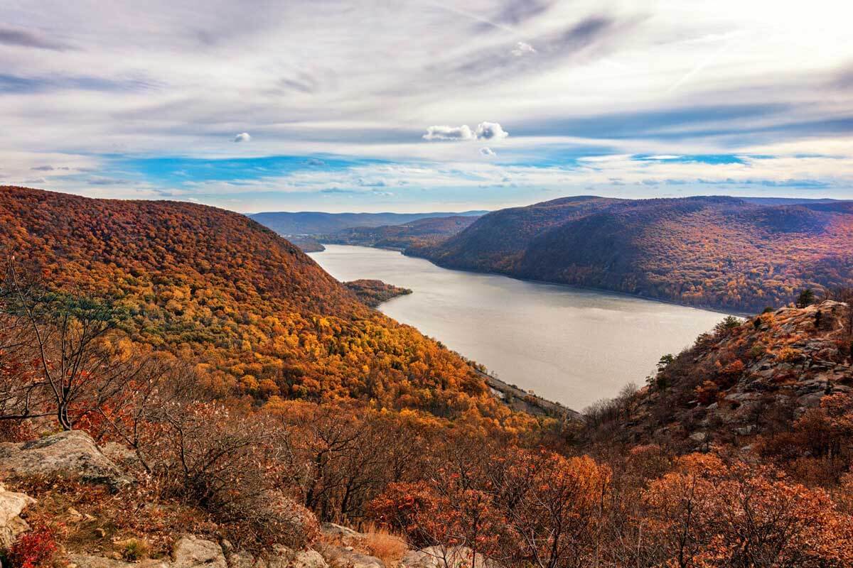
Bear Mountain
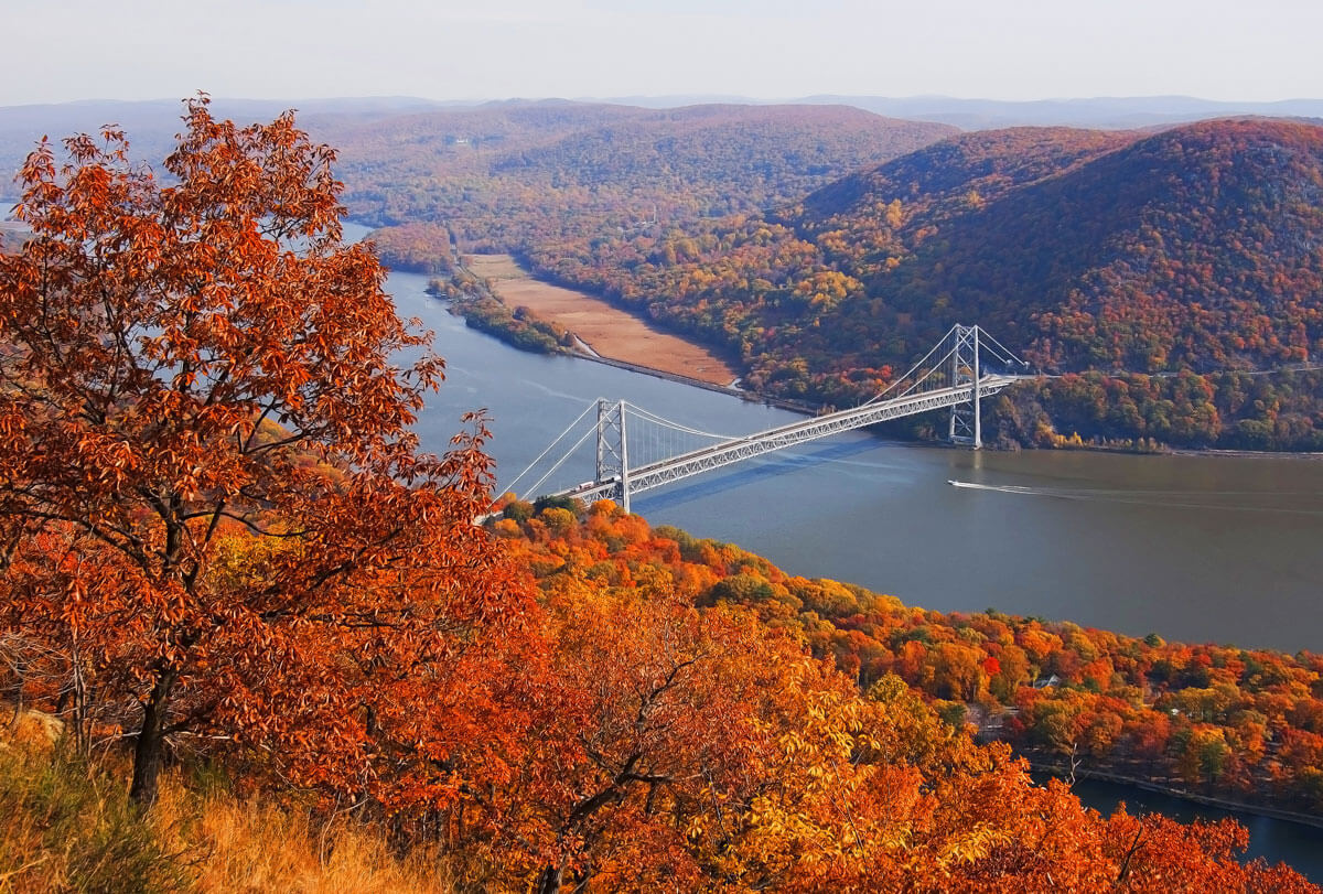
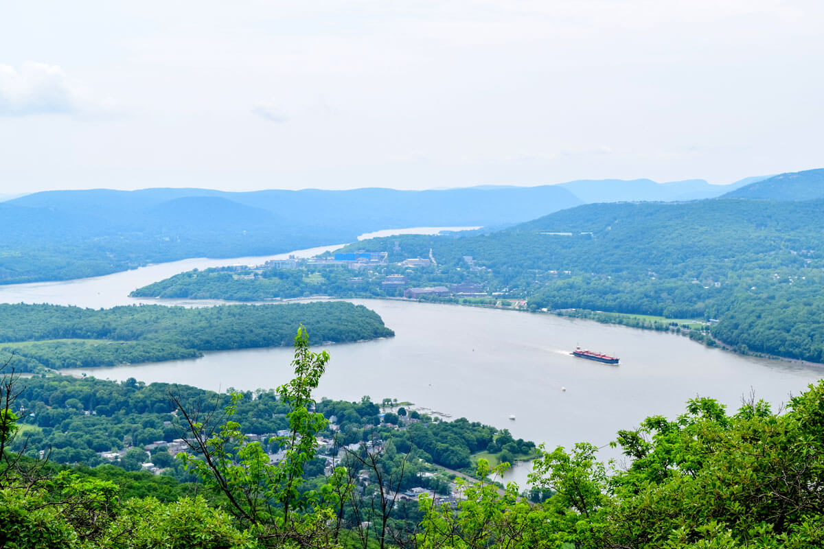
One of the most well-known hiking trails near NYC is none other than Bear Mountain, located west of the Hudson River. This scenic hike takes you on portions of the famous Appalachian Trail and the Major Welch Trail.
This historic area was once a major vantage point for British Soldiers during the American Revolution to control the area surrounding the river.
Today, hikers can enjoy the 3.7-mile hike to the summit of Bear Mountain, at the Perkins Memorial Tower, with a panoramic view of the Hudson, Bear Mountain Bridge, Anthony’s Nose (mentioned later in this list), and NYC in the distance!
On the trail, you’ll encounter a light rock scramble (it’s easier to go counter-clockwise and ascend rather than go down), but altogether this trail is perfect for moderate-level hikers, and well worth the effort! For those looking to extend their day hike to a weekend trip, the Bear Mountain Inn is located near the trailhead and offers a great opportunity to visit the surrounding areas.
- Difficulty Level: Moderate
- Distance/Time from NYC: 46 miles, up to 1 hour by car, approximately 1 hour 40 minutes by bus, 1 hour 30 minutes by Metro-North (followed by taxi).
- Transportation Options: Car (with tolls if taking the George Washington Bridge coming from New Jersey into NYC), Shortline bus from Port Authority Bus Terminal to Bear Mountain, or take Hudson line Metro-North train from Grand Central to Peekskill, followed by a 15-minute taxi.
- Length & Type of Trail: 3.8 miles, loop
- Cost: $10 for parking
- Parking: Parking is available near Bear Mountain Carousel, or at Bear Mountain Inn
Arden Point and Glenclyffe
Located in Garrison, NY, about one hour outside of the city, this is one of the best hikes near NYC for all skill levels. The trail begins at Arden Point and eventually merges with Glenclyffe and loops back around, 3.8 miles altogether and can be completed anywhere between 2.5-5 hours.
Along the hike, you’ll see abandoned houses overtaken by woods, a waterfall, and even a bamboo forest with picnic tables nearby for a mid-hike lunch.
Upon reaching Arden Point, a spectacular viewpoint shows West Point Academy across the Hudson River. During the trail, signs point to the historic overlook of Beverly Dock Road, signifying the area Benedict Arnold used to escape during the Revolutionary War.
Here, you’ll also be able to see Bear Mountain Bridge and Sugarloaf Hill. Continue walking to reach an open field with Castle Rock visible across on the hill.
Because this trail is relatively flat with slow inclines, it’s one of the many day hikes near NYC where children and dogs can come along too! It’s also one of the public transportation-friendly hiking trails near NYC, since the Metro-North train from Grand Central leaves you right at the trail start.
- Difficulty Level:Easy
- Distance/Time from NYC: 54 miles, 1 hour 10 minutes by car, 1 hour 20 minutes via Metro-North.
- Transportation Options: Car (with tolls on the George Washington Bridge coming from New Jersey into NYC ($16), or take the Metro-North train from Grand Central to Garrison Station.
- Length & Type of Trail: 3.8 miles, loop
- Cost: Free entrance
- Parking: Free parking at Garrison Metro-North Station available on weekends, and $3.50 for 16 hours on weekdays
Old Croton Aqueduct
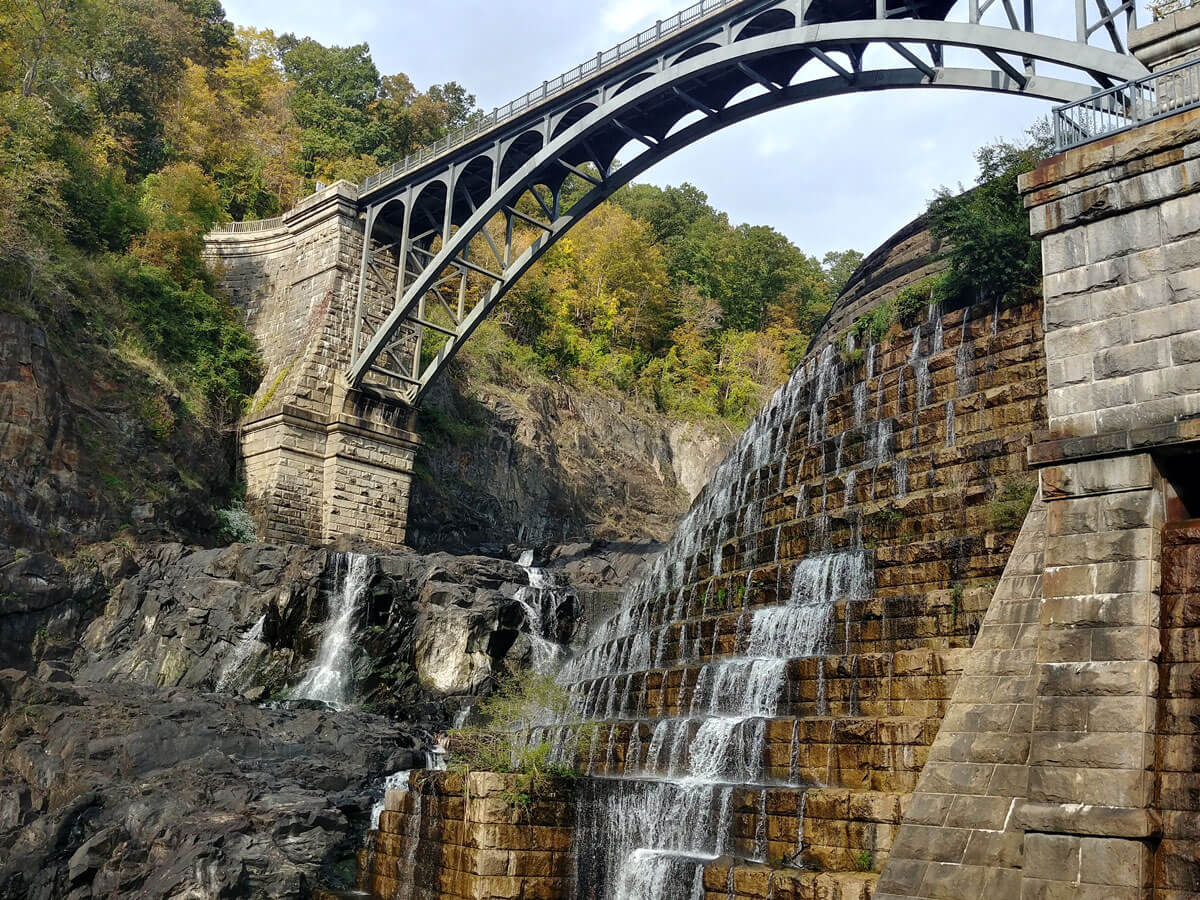
For a tour of the more historical hikes near NYC, head north to see the Old Croton Aqueduct, New York’s first water source built between 1837-1842. The former 41-mile long aqueduct that ran from Croton to Yonkers has now been turned into a state park providing several of the best hiking trails near NYC.
The trail currently has 26 miles of walkable paths, with several shorter routes beginning in different locations leading north towards Croton. For a well-rounded trip with great sights, we recommend following the aqueduct from the town of Ossining to Quaker Bridge.
This 5.5-mile hike is rated easy-moderate, and takes you through the town of Ossining, where you can head into the Ossining Community Center building’s Visitor Center to learn more about the aqueduct’s history and construction.
Passing through historic bridges and structures from the aqueduct, you’ll first hear, and then eventually reach the waterfalls of Croton River Gorge. At the end of your hike, hop on the Metro-North from Croton-Harmon or grab an Uber back to Ossining Station where you started (or back to the city!).
Or, for a longer challenge, take the 10 mile long out-and-back trail from Ossining to New Croton Dam. While this trail isn’t as picturesque as some of the other day hikes near NYC mentioned on this list, its rich history and marvelous infrastructures are still worth checking out!
- Difficulty Level: Easy-moderate
- Distance/Time from NYC: 32 miles, 40 minutes by car, 1 hour 20 minutes via Metro-North.
- Transportation Options: Car, or take the Metro-North train from Grand Central to Ossining.
- Length & Type of Trail: Several trails, with Ossining to Quaker Bridge being 5.5 miles, point to point
- Cost: Free entrance
- Parking: Street parking available
Anthony’s Nose
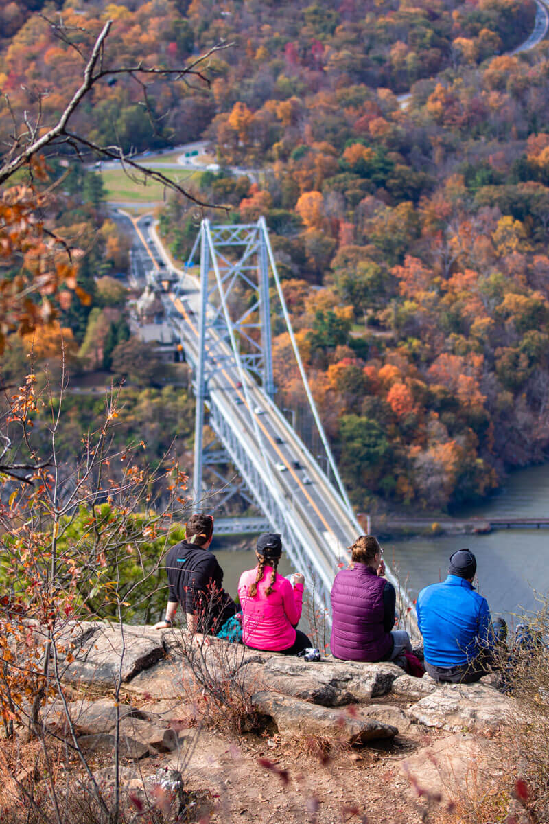
The journey up to Anthony’s Nose is one of the best hiking trails near NYC for beginners, with great views of the Hudson River and a chance to walk along the famous Appalachian Trail. The trail itself is less than 2 miles, with lots of rest points and cozy spots that are perfect for picnicking along the way.
This hike may seem quite steep in the beginning by climbing a stone staircase, but this covers the majority of the elevation gain, and eventually the path levels out for an easy ascent up to the peak. Once you reach at the top, you’ll see clearly towards Bear Mountain Bridge and Bear Mountain.
The trail is easily reached by car with roughly an hour drive, a great option for families looking to do some hiking around NYC!
- Difficulty Level: Easy (with a bit of a steep climb, but only in the beginning)
- Distance/Time from NYC: 44 miles, 45-60 minutes by car.
- Transportation Options: Car. Length & Type of Trail: 1.9 miles, out and back.
- Cost: Free entrance
- Parking: Parking is available along the shoulder of Route 9D north of Bear Mountain Bridge.
Stairway to Heaven Trail
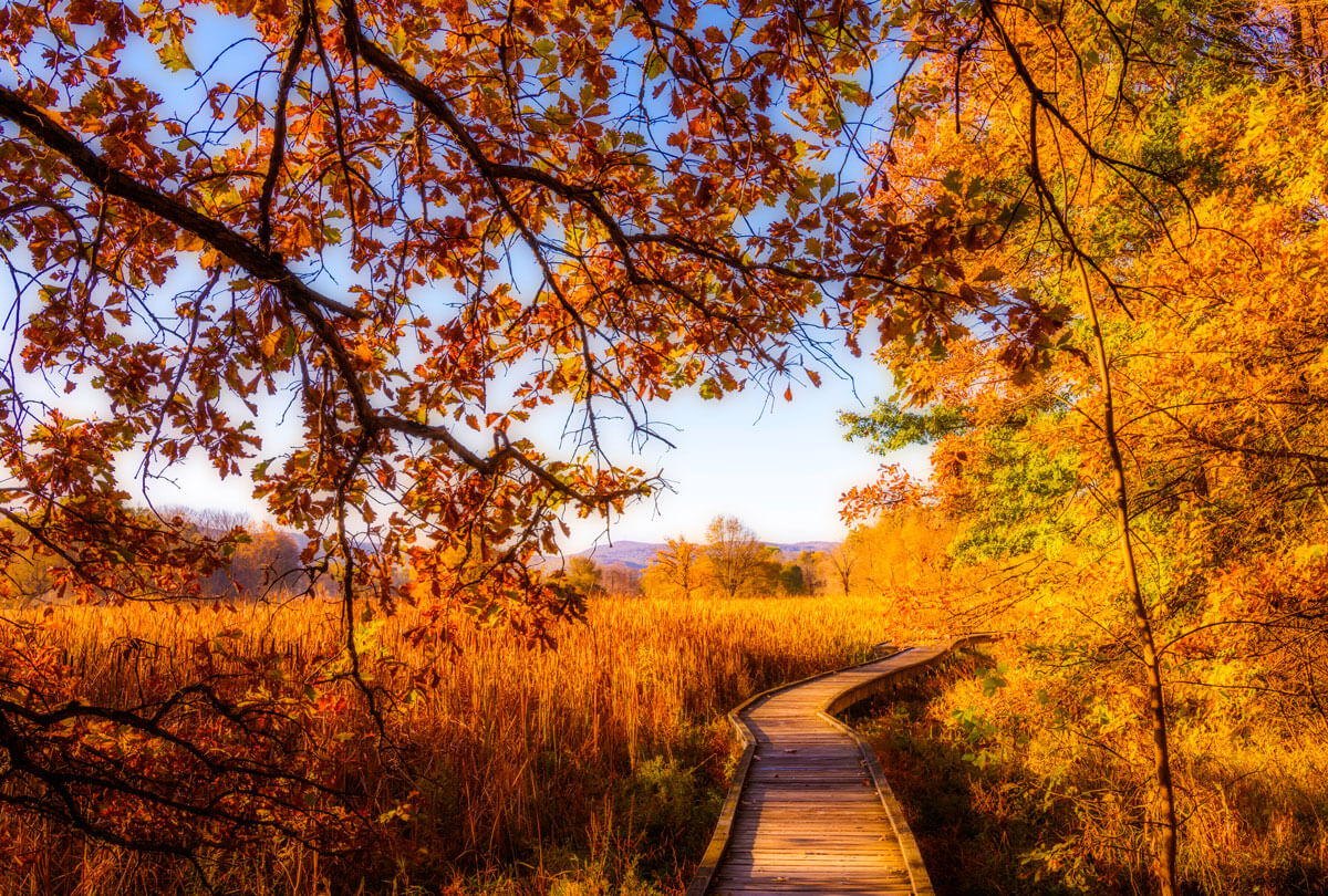
Walk along the Appalachian Trail for some beautiful hiking around NYC in the Wawayanda State Park. Three trails are available in the area, featuring a diverse range of natural habitats, including forests, open meadows, and marshy plains.
The region features three trails of ranging difficulty. The easiest trail takes you on a stroll along the Pochuck Boardwalk, a wooden walkway placed over marshland with great views, but not physically demanding.
The more difficult trail is short, but involves steep climbs, with rocks placed as steps, hence its name. This park has something for everyone, all with rewarding views despite which trail visitors choose.
Because of the varied difficulties, these hiking trails near NYC draw visitors of all skill levels. Along the way, you might even run into hikers making the journey along the famous Appalachian Trail from Georgia to Maine!
Complete your trip to the Wawayanda State Park by heading over to Penning’s Orchard nearby, and their adjacent restaurant to taste farm-fresh food, or their cidery’s taproom to try their hard cider and craft beer. For those with children, visit the Heaven Hill bakery for their donuts and ice cream!
- Difficulty Level: Trails range from easy to moderate
- Distance/Time from NYC: 50 miles, 1 hour 10 minute drive.
- Transportation Options: Car
- Length & Type of Trail: 1.5 miles for Pochuck Boardwalk, 2.9 miles for Stairway to Heaven, both out and back
- Cost: State park entrance. Weekdays $5 for NJ residents, $10 for non-residents. Weekends and holidays $10 for NJ residents, $20 for non-residents.
- Parking: Parking can be found near the trail base, off route NJ 94, close to Heaven Hill Farm and Garden Center.
Storm King Mountain
Most people know of Storm King as home to the sculpture park of the same name, but the trail leading to Storm King Mountain is perhaps one of the best hikes near NYC for its proximity to the city, as well as its forgiving difficulty level. The loop itself is 2.4 miles, with a peak of 629 ft, with a rewarding panoramic view of Hudson Valley at the top.
This family-friendly trail averages around 3-4 hours to complete and is perfect for those who may not have the time for any of the other full-day hikes near NYC mentioned on this list.
It’s recommended to go clockwise on this trail, because of a small rock scramble towards the beginning that is easier to ascend rather than go down.
For those traveling by car to Storm King Mountain, the museum nearby is a unique and picturesque sculpture park, and a great way to end your day.
- Difficulty: Moderate
- Distance/Time from NYC: 54 miles, 1 hour 10-minute drive.
- Transportation Options: Car (with tolls on the George Washington Bridge coming from New Jersey into NYC, Metro North from Grand Central to Beacon Station followed by a 30-minute taxi or Uber, Bus from Port Authority to Storm King Art Center (1 hour 40 minutes).
- Length & Type of Trail: 2.4 miles, loop
- Cost: Free entrance and parking. If visiting Storm King Art Center, admission and included parking are $18
- Parking: Parking lot can be found off Rt. 9w, with a historical marker nearby leading towards the trail
Giant Stairs Trail
This particular hike, found in the Palisades Interstate Park is not for those with a faint heart (or with weak-knees!), living up to its name as the most challenging trail in the state park. This is one of the best hiking trails near NYC for rock climbers looking for a challenge, to be rewarded with great views.
While the trail itself is only 4.3 miles, the “Giant Stairs” refer to an approximately 1 mile stretch of rock scrambles along the Hudson River. The trail also features steep and rocky paths high up on the hills along the Hudson, so hiking boots are strongly recommended for this trail! Once making it past the Giant Stairs, admire the view of the Tappan Zee Bridge overlooking New York across the water.
Because this is one of the more challenging day hikes near NYC, enjoy the solitude, or some good company in this less frequented trail. The Palisades Interstate Park is also home to over 30 miles of hikeable trails, if this one isn’t for you!
Reward yourself with a well-deserved meal at the State Line Cafe, or visit the Lookout Inn cafe and bookshop near the trailhead before heading back, after completing one of the most challenging hikes near NYC!
- Difficulty: Difficult
- Distance/Time from NYC: 18 miles, 25 minutes.
- Transportation Options: Car (with tolls if taking the George Washington Bridge coming from New Jersey into NYC).
- Length & Type of Trail: 4.3 miles, loop
- Cost: Free entrance and parking
- Parking: Free parking available at the State Line Lookout. Exit from the Palisades Interstate Parkway
Staten Island Greenbelt
The various natural spaces that make up the Staten Island Greenbelt is one of the best hiking trails near NYC that doesn’t require a car, and is easily accessible from Manhattan. The sheer size of the Staten Island Greenbelt (3 times bigger than Central Park!) makes this park rich in its trails, and its multitude of natural habitats.
This nature preserve has six trails to choose from, with varying skill level requirements and physical preferences. Of the six trails, two lead to the peak of Todt Hill (390 ft in elevation), the highest naturally-formed pinnacle in New York, and one of the highest natural points between Florida and Maine.
Reaching Todt Hill grants you a panoramic view of the surrounding areas in Staten Island, including the Verrazzano Bridge. Different terrains within the park feature a wide variety of trees uncommon in New York, and draws crowds from the birdwatching community as well, making it one of the best hikes near NYC for nature enthusiasts of all backgrounds.
To take better advantage of learning about its nature and wildlife, the Staten Island Greenbelt Conservancy leads free tours every Wednesday, as well as audio tours to learn more about the park’s history and environment.
- Difficulty Level: The 6 trails range from easy to difficult.
- Distance/Time from NYC: 23.5 miles, 40 minutes by car. Ferry/bus option takes approximately 1 hour 10 minutes from Manhattan.
- Transportation Options: Car (with tolls on both sides of the Verrazano Bridge), or Staten Island Ferry to bus S62 to Bradley Avenue, followed by the S57 bus to Rockland and Brielle Ave. Station.
- Length & Type of Trail: Loop and Point to Point trails. Length depends on the trail taken.
- Cost: Free entrance. Ferry to/from Staten Island is free, followed by bus ($2.90)
- Parking: Free parking available at Greenbelt Nature Center, Greenbelt Recreation Center, Willowbrook Park, LaTourette Golf Course, and the Field of Dreams
Sands Point Preserve Hike
Head over to the Sands Point Preserve in Long Island for a mix of historical, cultural, and nature-filled activities, all easily packed into one day! The preserve is home to 216 acres of woodland, with 6 marked paths perfect for hiking around NYC.
The area is not only great for its trails, but also for its enchanting architecture and the fascinating history behind the property! The two mansions that can be seen on the preserve are the Hempstead House, and Falaise, both part of the former Guggenheim estate. Tours are available inside the mansion for a chance to view opulent antiques, paintings, and decorated rooms secluded within the green landscape.
The six trails offer well-maintained pathways, taking you through open fields and a pond on the preserve, and perfect for those in search of easy hikes near NYC.
The grounds are closed on Mondays and Tuesday for maintenance purposes.
- Difficulty Level: 6 trails, all easy.
- Distance/Time from NYC: 28.5 miles, 45 minutes by car, or 1 hour by LIRR.
- Transportation Options: Car or take LIRR’s Port Washington Line to final stop followed by a 5 minute uber or taxi.
- Length & Type of Trail: 1.9 miles, loop
- Cost: $15 per car for parking and admission, $4 for walk-ins
- Parking: Parking can be found right after entrance onto the preserve
Verkeerderkill Falls
Head north about an hour and a half away from the city to visit the beautiful landscapes surrounding the tallest waterfall of the Shawangunk Mountains. This hike spans 8.3 miles, with the additional option of visiting the trail’s Ice Caves (except Winter, when the Ice Caves are closed), formed in the crevice of the mountain where ice and snow are trapped all year round.
While the trail may be long with some light rock scrambling for some areas, it’s generally considered an easy-moderate hike. Along your way, you’ll also reach Sam’s Point, a beautiful cliff overlooking the woods down below–great for photos and a picnic, if the spot hasn’t been claimed by the many hikers who come for this rewarding trail.
The trail will lead you to an open field, so be prepared to walk in the sun for a good portion of it! This day trip can take anywhere from 4.5-7 hours (depending on if you visit the Ice Caves) but is one of the best hikes near NYC for its gorgeous views, a cooling waterfall, and serene wildlife.
- Difficulty Level: Moderate
- Distance/Time from NYC: 85 miles, 1 hour 40 by car, approximately 2 hours 45 minutes by bus (followed by taxi).
- Transportation Options: Car (with tolls if taking the George Washington Bridge coming from New Jersey into NYC), or take Shortline bus from Port Authority Bus Terminal to Ellenville, followed by 15-minute taxi to Sam’s Point Preserve.
- Length & Type of Trail: 8.3 miles, loop
- Cost: $10 for parking at the visitor’s center
- Parking: Parking available at Sam’s Point visitor’s center, but it’s recommended to arrive early or go on weekdays
Lake Skenonto Loop
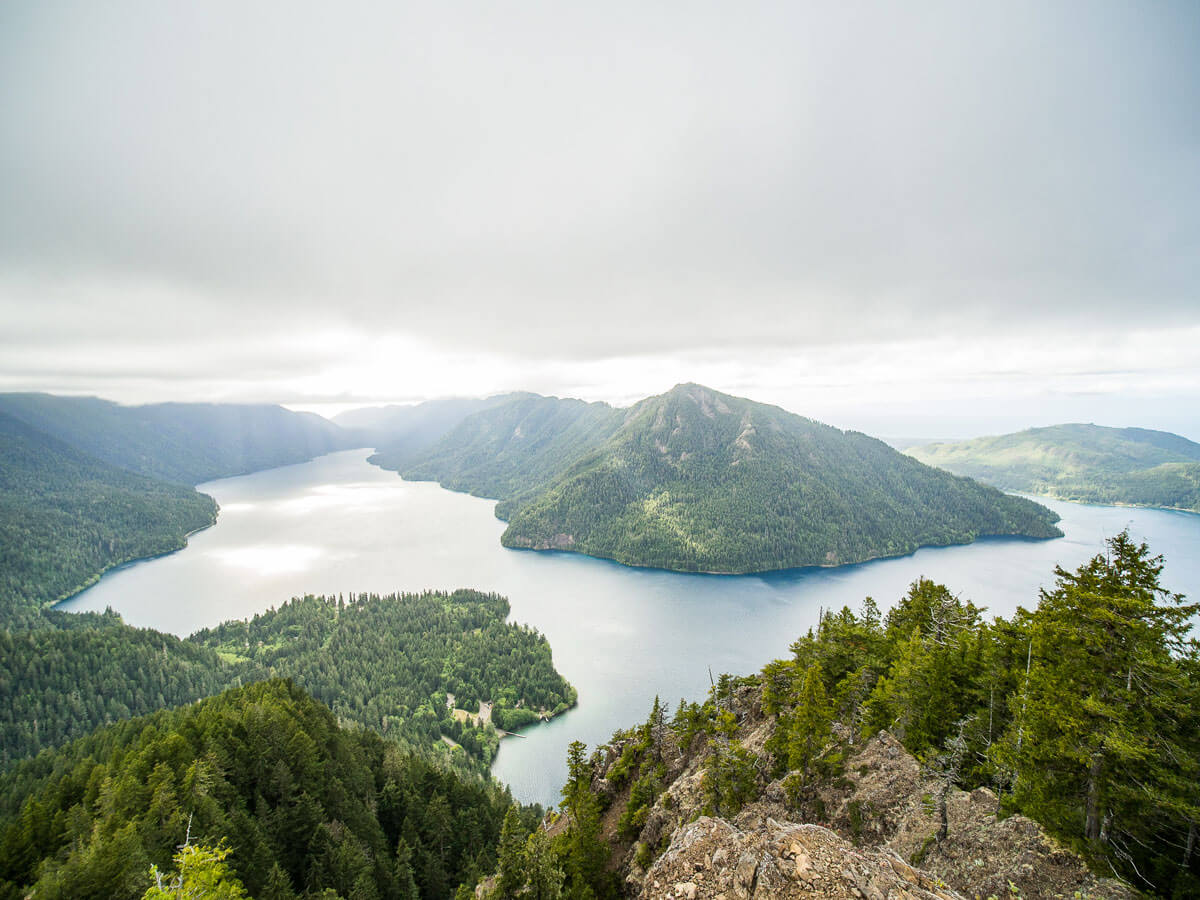
Harriman State Park, located in the Palisades region of Upstate New York offers over 200 miles of hiking trails near NYC. Accessible via public transportation or an hour-long car ride, the Lake Skenonto Loop is a scenic 8-mile long route (roughly 5-6 hours to complete), taking you into the forest and to the foot of Black Ash Mountain.
With plenty of ideal picnicking locations and a walk around the shores of breathtaking Lake Skenoto, this is one of the best hiking trails near NYC if you’re looking for a trip that’s less heavily trafficked and offers more secluded walkways.
Harriman State Park also offers camping locations around, and your hike can easily be extended into a peaceful weekend trip from NYC.
Be sure to pack a lunch and have it along the banks of the lake, before continuing towards the fields around Black Ash Swamp to conclude your trip! Harriman State Park is the second-largest state park in New York, with tons of options for day hikes near NYC.
The surrounding area nearby also is home to Dater Mountain Nature Park and Sterling Forest State Park, so if Lake Skenonto isn’t for you, you’re sure to find great alternatives nearby for some great hiking around NYC.
- Difficulty Level: Moderate
- Distance/Time from NYC: 42 miles, up to 1 hour by car, and 1 hour 15 minutes by train to Tuxedo Station .5 miles away from trailhead.
- Transportation Options: Car (with tolls on the George Washington Bridge coming from New Jersey into NYC, Shortline bus from Port Authority Bus Terminal, or NJ Transit Port Jervis line from Penn Station to Tuxedo Park (Transfer required at Frank R Lautenberg Secaucus Upper Level)
- Length & Type of Trail: 8.1 miles, Loop
- Cost: Free entrance into state park
- Parking: Park in lower lot zone 4515 on East Village Road. Free parking on weekends, $3 on weekdays (must pay online)
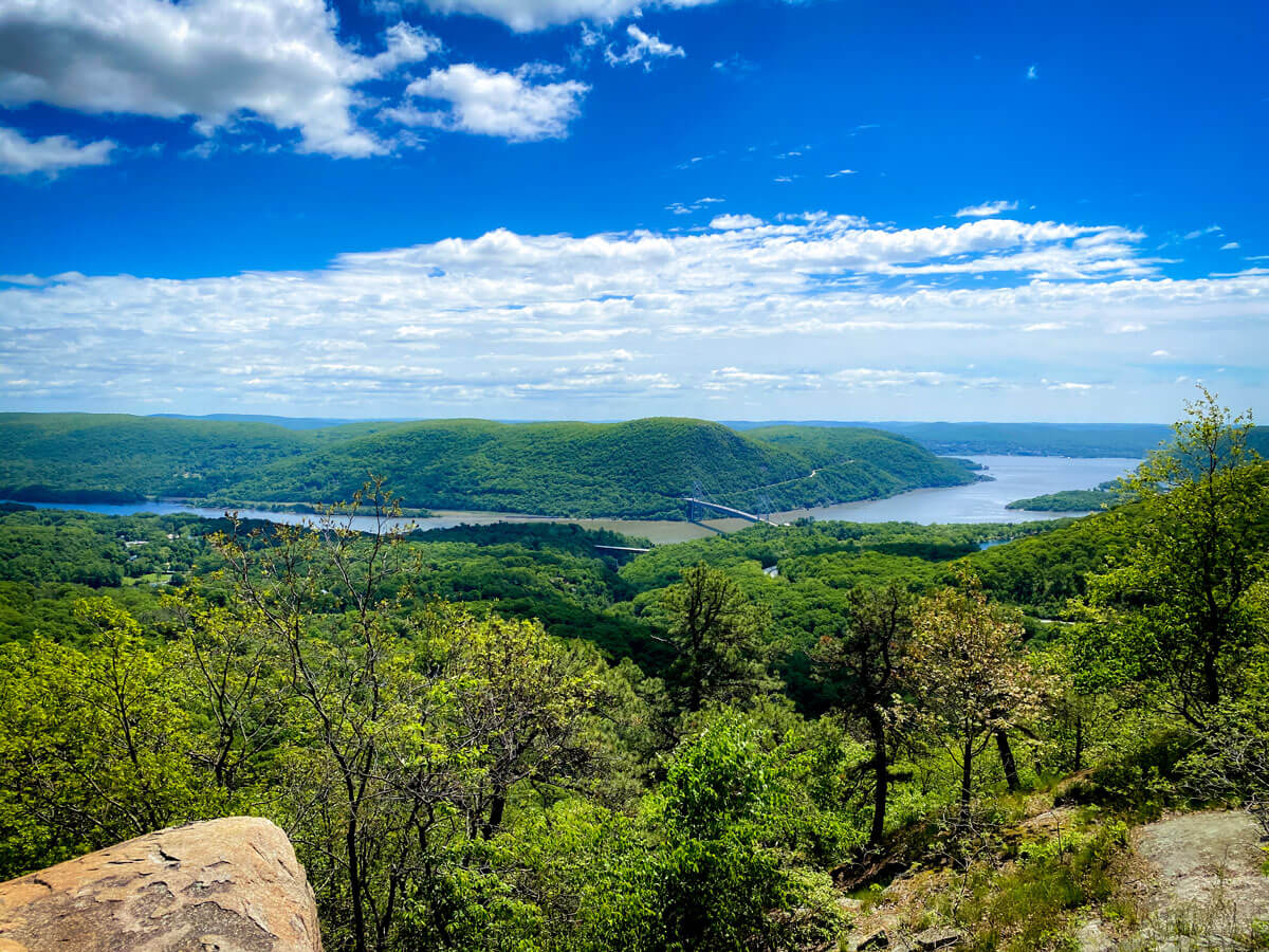
Breakneck Ridge
One of the more frequented hikes near NYC, Breakneck Ridge is a convenient option for the many New Yorkers without a car, and want to go far away from the city, but make it back to Grand Central at a reasonable hour. Spectacular views of the Hudson River, West Point Academy, and adjacent mountains can be seen at the summit.
The versatility of the trails is also another attractive feature of Breakneck Ridge, as there are various trails that begin at the same point, ranging from moderate to difficult, all requiring some steep uphill climbs.
The peak of Breakneck Ridge is over 1200 feet in elevation, and all trails require some light rock scrambles towards the entrance. This trail is ideal for more experienced hikers, or those looking to challenge themselves–for some lighter day hikes near NYC in this area, perhaps Bull Hill (mentioned on this list) is more appropriate.
Located between the towns of Cold Spring and Beacon, it’s easy to make a cozy weekend trip out of visiting Breakneck Ridge. If you choose to stay in Cold Spring, there are lots of quaint antique stores, cafes, and B&Bs in this secluded and charming town.
The town of Beacon has the contemporary art museum, Dia:Beacon definitely worth visiting, if choosing to travel by car.
- Difficulty/Length/Type of trail: Varying trails ranging from moderate to difficult, from 2.5 miles to 7.2 miles, all loops.
- Distance from NYC: 60 miles (1 hour 30 minutes by car), 1 hour 30 minutes by Metro-North.
- Transportation Options: Car (with tolls on the George Washington Bridge coming from New Jersey into NYC, or Metro-North from Grand Central to Breakneck Ridge Station (only on weekends), follow route 9D to the start of trail. On weekdays, take Metro-North to Cold Spring, with an hour walk (or 5 minute uber/taxi) from the station to the trailhead.
- Cost: Free Entrance
- Parking: The parking lot just north of the trailhead is small, but it is also possible to park on the road nearby
Bull Hill (Mt. Taurus)
The trail for Bull Hill is just a mile away from its more famous counterpart, Breakneck Ridge, and offers amazing views for hikers of all skill levels. Bull Hill leaves you the option of taking the short loop (4.3 miles) or continuing onwards for the full loop (5.4 miles with a steeper incline) to reach the summit of Mount Taurus.
You’ll see great vantage points overlooking Cold Spring, West Point Academy, and NYC further away, with scenic rest points along the cliffs and greenery.
If choosing to go on the full loop, you’ll pass by Cornish Estate, remnants from an estate built in 1910 belonging to Edward Joel Cornish, the president of the National Lead Company. The estate burned down in 1958, but the ruins are still a beautiful site to explore today.
End your day hike by visiting Little Stony Point across the road from the trailhead to sit by the Hudson River and unwind after!
- Difficulty Level: Easy-moderate (if taking full loop trail)
- Distance from NYC: 60 miles (1 hour 30 minutes by car), 1 hour 30 minutes by Metro-North.
- Transportation Options: Car (with tolls on the George Washington Bridge coming from New Jersey into NYC, or Metro-North to Cold Spring followed by a 5 minute uber or taxi.
- Length & Type of Trail: 4.3 miles (short loop), 6.6 miles (full loop)
- Cost: Free Entrance
- Parking: Parking lot near Little Stony Point, north of trailhead
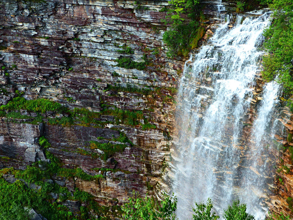
Kaaterskill Falls
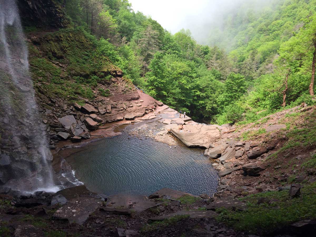
The Catskills have long been a nature-filled paradise and escape for New Yorkers, whether it’s to go on a camping retreat, or on some of the best hikes near NYC that the state has to offer! Kaaterskill Falls is a two-tiered waterfall, and reaching over 260 feet, it’s featured in many works of art, such as the legend of Rip Van Winkle, among others.
Today, seeing one of the largest waterfalls in Upstate New York is a breeze to get to from Manhattan, and makes for some great hiking around NYC. The Kaaterskill Falls trail takes you towards a viewing platform overlooking gorgeous views of the Kaaterskill waterfall, and the surrounding woods.
The trail is well marked and firmly paved with sturdy stairways, making it a great option for hikes near NYC for all skill levels and physical abilities.
To extend the trip further, and to give yourself an extra challenge, continue along the trail to the bottom of the waterfall. This stretch of the trail may prove to be a bit difficult for novice hikers because of the steep descent leading down, but well worth the journey for the amazing views that surround you at the bottom.
- Difficulty Level: Easy (moderate-difficult if walking down to bottom of waterfall)
- Distance/Time from NYC: 120 miles, between 2 hours- 2 hours 30 minutes away.
- Transportation Options: Car (with tolls if taking the George Washington Bridge coming from New Jersey into NYC, and a toll road on I-87).
- Length & Type of Trail: 2.6 miles, out and back
- Cost: Free entrance
- Parking: Park at the designated locations at the end of Laurel House Road, or Scutt Road, near Haines Falls. This area is known for fines and towing if parked illegally on the street
See our guide to best weekend getaways in the Catskills to fill an entire weekend of fun in the region!
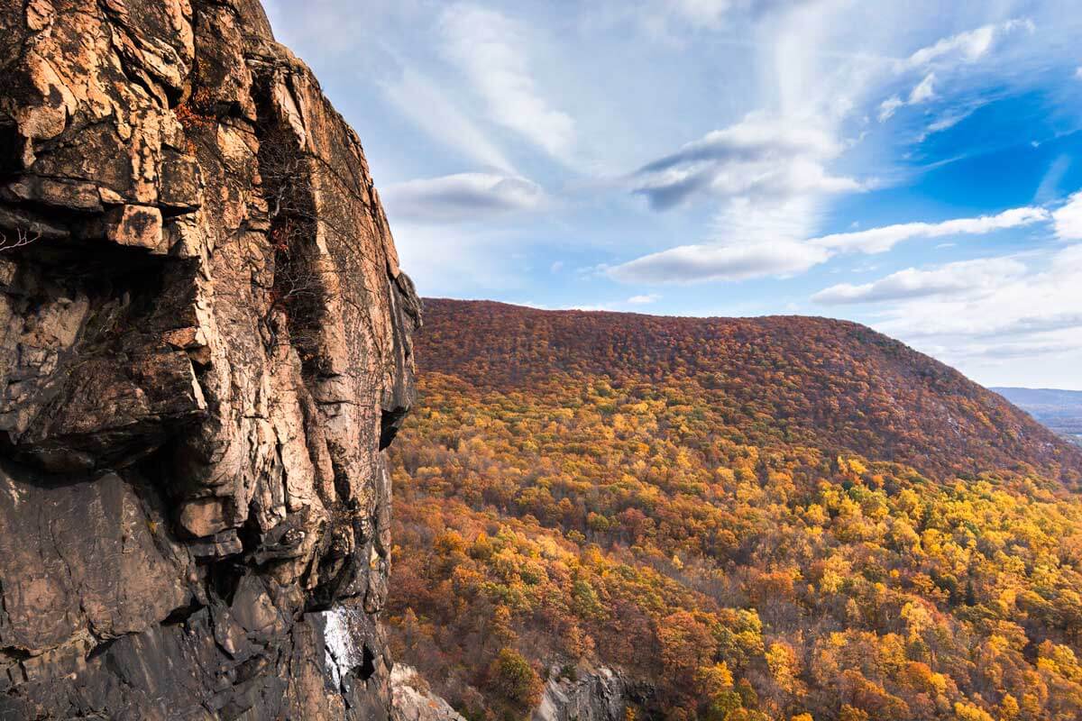
Popolopen Torne
For more seasoned hikers, visit the Popolopen Torne trail in the Hudson Highlands for a rewarding panoramic view of Bear Mountain, Bear Mountain Bridge, West Point Academy, and the Hudson River at the peak of the mountain.
This trail for the most part is leveled, but you’ll encounter rock scrambles up to the top, along with crossing a bridge across a stream that’s sure to make you appreciate the beauty and serenity of the woods.
At the top, enjoy the view alongside a memorial site commemorating late veterans of the country, next to a structure made of painted rocks carried up from the bottom by those wishing to pay their respects, known as the Trail of the Fallen.
Three trails are available here, following the same path for the first 1.5 miles, but those wishing to reach the summit should follow the blue-blazed Timp-Torne Trail.
- Difficulty: Moderate-difficult
- Distance/Time from NYC: 50 miles, approximately 1 hour 15 minutes by car.
- Transportation Options: Car (with tolls if taking the George Washington Bridge coming from New Jersey into NYC).
- Length & Type of Trail: 4.3 miles, loop
- Cost: $10 for parking
- Parking: Hiker parking at 9w parking lot, about ¼ of a mile from the Fort Montgomery State Historic Site where the trail begins
[line]
Did we miss your favorite day hike from NYC? Let us know in the comments below and be sure to bookmark this guide for later if you found it helpful! Happy hiking!


Thanks for this very good comprehensive list and description of hikes near NYC. I have done most of them. In the hike ARDEN POINT AND GLENCLYFFE you mention the there is a good view of West Point and Bull Hill across the river. Correction: Bull Hill is on the same side of the Hudson as this hike. Bull Hill is between Cold Spring and Breakneck Ridge. Perhaps you meant to say Storm King which is across the river?
Anyway, thanks again.
Thanks for catching that mistake!